Beeleigh Locks, Essex
Not all researchers follow the common model
In the world of the paranormal, the standard model in relation to suitable locations
with a haunting to investigate is usually to identify such a location or, on
rare occasions, be approached by someone affected by a haunting or some other
form of alleged paranormal occurrence at their property.
Clearly, whilst this model works well for most, it is far removed from the one
that we follow, where locations, often obscure and with no previous history of
paranormal phenomena, are usually identified, via Laura’s ability to tap into
the atmosphere there.
This approach has continued to work well for us, although
admittedly it is a stretch to call it a model.
In the general course of everyday life, many such locations, be they buildings
or outdoor areas, are identified but often never progressed any further by us.
We simply note what we’ve observed and move on.
The majority of what we’ve written to date takes place after some progress has
been made with a location, so we thought that it would be interesting, for a
change, to document the beginning of a potential case, so we can share with you
how it commences and, hopefully, provide further updates as things progress, if
at all.
We are fully aware that documenting a potential case may
turn out to be a damp squib from a reading experience, but it may still be of
interest to some, who are perhaps leaning towards the model that we follow.
To facilitate this, we will be completely transparent and disclose locations
and other identifying factors.
Some matters will be pending and may always remain so, therefore, with this in
mind, if anyone is able to help with any aspect of the case as we progress, we
would welcome any contribution to the discussion.
We hope that this will provide some insight.
Beeleigh Locks,
Essex – 27th June 2019
The day started innocuously as any, with the school
holidays soon to commence, we decided to take a walk to the weir at Beeleigh
Locks, simply for the opportunity to get some fresh air and take some
photographs.
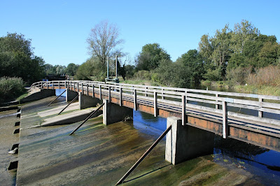 |
| Beeleigh Falls |
The paranormal could be no further from our mind, so we had
no reason to take any recording equipment, although I carried my notebook
The Locks are where the River Blackwater, River Chelmer and, the Chelmer and
Blackwater Navigation (canal) converge, near to the ruins of Beeleigh Abbey, part
of which is now the home of the Foyle family, of renown bookshop fame.
Here, you will find a large weir, known as Beeleigh Falls, canal locks and a couple of pools, as well as the remains of a former Victorian
steam powered Corn Mill.
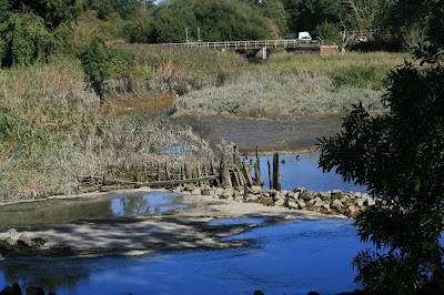 |
| The original weir |
The weir that you can see today was constructed in the 1950’s, replacing a
previous
weir (the remains of which are
a short distance away), which was destroyed on the evening of the 31
st
January 1953, in the devastating East Coast Floods.
In the UK alone, 531
people tragically lost their lives that night and remains a grim memory in East Anglia even today.
Turning to the Mill, it was thought likely that there had
been a Mill at the location at least 1,000 years, a watermill being recorded as
being there as early as the Doomsday Book of 1086. The last mill was destroyed,
by fire, in 1875 and never rebuilt, its remains now protected, with plans, well
advanced, to reopen as a museum.
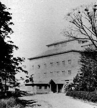 |
| A rare image of the Corn Mill, caught in its prime |
Approaching the Locks, we decided to stop for a while and
take some photographs from the weir, looking down the River Blackwater to
Maldon in the distance.
After spending some time in the area, waiting for people
to clear so we could take some unobstructed photographs, we decided to take the
path to Beeleigh Abbey, following the path through a wooded area, leading away
from the canal and, across a bridge, where the sorry remains of the pre-1953
weir lay, scattered beneath the bridge, the debris trail leading down to an old
pool.
We continued walking and eventually came to the end of the track, finding ourselves
at the end of a metalled road, outside what remained of Beeleigh Mill.
Beeleigh Mill
Whilst we were outside the old Corn Mill, Laura, without
warning, began to receive information psychically, over a period of 9 minutes.
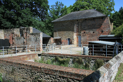 |
| The Corn Mill today |
As I paused, to take photographs of the Mill, Laura turned to me and advised
that she had been given the word ‘Carving’.
Taking notes, I pressed her to be more specific.
Laura felt that she needed to find a carving, sculpture or similar, on the side
of a tree.
I asked what the carving was, but she was unable to progress this
any further.
As I continued to ask questions, Laura advised that she’d
received the name, probably a surname, ‘Clindell’ – this was a male and was
immediately followed by the name ‘John’, possibly in relation to ‘Clindell’
i.e. ‘John Clindell’.
Beeleigh Falls House
At this point, we decided to look for the tree with the
carving / sculpture and moved on, following the road around the Mill, heading towards
Beeleigh Abbey.
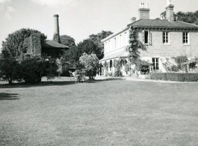 |
| An old photograph of Beeleigh Falls House, with the Corn Mill behind it |
As we passed the entrance to Beeleigh Falls House, Laura picked up the name
‘Beatrice’, who she advised was connected to the ‘John’ that she’d picked up a
couple of minutes earlier. She then she picked up the name(s) ‘Beth /
Betherley’ (pronounced Beverley).
I decided to let Laura continue and said nothing as we walked, as not to
disturb her focus.
Laura then received ‘Quaits / Quaites’, but unsure as to
its context.
Nothing further was forthcoming for now, the flow of
information had ceased.
As we were unsure as to how much further along the track
the Abbey was, being unfamiliar with the area and not planning to spend as long
as we had on our walk, we decided to turn around and retrace our steps back to
the weir.
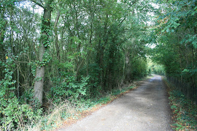
Back to the wooded area
Upon reaching the path back through the woods, adjacent to the Mill, Laura
picked up ‘Candle Maker’, but nothing else.
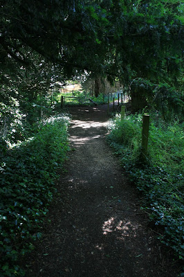 |
| The track through the wooden area, looking towards the Corn Mill |
I took the decision to let Laura walk along the track a bit, whilst I scouted
around for a carving (or similar) on any of the trees in the area, but with no
luck.
Dejected, I briskly walked along the path and soon caught
up with Laura.
Reaching Laura, she told me that she’d been getting the word (or possibly the name),
‘Clean’ or ‘Clein’ – pronounced clean, during
the entire time that we’d been in the area, but just couldn’t get the context.
We continued walking.
A little further along the path, before we had reached the bridge over the remains
of the original weir, Laura picked up ‘Hedgerow Drive’.
Laura then stopped and turned to me, advising that she was
sensing an ‘old style car – white’, ‘an American style square car’.
As we were in the middle of the English Countryside, not
stateside, I immediately thought of a Mk1 Ford Cortina.
I described the vehicle to Laura, but she wasn’t sure.
This was something that we could easily check back home, so I parked it......
Next, she advised that she was observing the car
travelling towards her, along a road that had two bends (see Laura’s sketch
below) – with two people in the car.
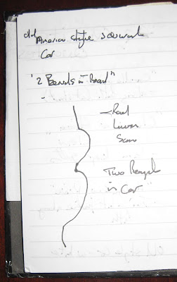 |
Mark’s writing, Laura’s sketch, we hope to improve both our
writing style and artistic skills soon.... |
Nothing else was forthcoming and we soon left the wooded
area and retraced our steps along the canal path.
As we continued our walk, passing Maldon Golf Club
Clubhouse, Laura advised that she had been picking up the name ‘Ken D’ since we
arrived at the weir, until we left the area.
Summary
At home, adopting my usual practice, I soon set about reviewing my notes and
summarising what Laura had picked up.
With no audio recorded, I had to take the timings from
the photographs that I’d taken along the way and noted that Laura had received
all the information from 09:52am to 10:01am (not including the information
disclosed on the walk past Maldon Golf Club), a period of 9 minutes, as previously
discussed.
Altogether, I had noted that Laura had picked up the following
information:
1. At
the Steam Mill, Laura got:
a. the word ‘Carving’; and
b. ‘Clindell’
– name of a male, followed by ‘John’, possibly in relation to Clindell.
2. At
the entrance gate to Beeleigh Falls House, Laura received:
a. the
name ‘Beatrice’, who was connected to ‘John’; and
b. the
name ‘Beth / Betherley’ (pronounced as Beverley).
3. Just
past Beeleigh Falls House, Laura was given ‘Quaits’ or ‘Quaites’
4. Back
at the start of the path through the wooded area, next to the Steam Mill, Laura
picked up:
a. ‘Candle
Maker’; and
b. advised
that she had been getting the word, or possibly name ‘Clean or Clein’
(pronounced clean) throughout the time that we’d been in the area.
5. Along
the path through the woods, Laura received:
a. ‘Hedgerow
Drive’;
b. sensed
an ‘old style car – white’, ‘American
style square car; and
c. observed
the vehicle travelling towards her, along a road with two bends, with two
people in the car.
6. Walking
along the canal path, as we passed the Maldon Golf Club Clubhouse, Laura commented
that she had been getting the name ‘Ken D’ since we arrived at the weir.
Satisfied that I had noted everything, I then turned my attention to attempting
validating each piece of information, to determine whether or not this case was
worth pursuing any further.
Initial Fact Find
To my disappointment, my attempts to tie any of the
information down was frustrating, the only positive being the positive
identification of the vehicle noted in 5 b. above – the old, American Style
white car.
As I alluded to in my notes, my initial feeling when Laura first mentioned this
vehicle was that it was an early Ford Cortina.
Finding some shots of a white example online, I asked Laura to take a look, who
immediately verified the vehicle that she had ‘seen’ as a white Mk1 Ford
Cortina, which was available in the UK from 1962 to 1966 inclusive.
 |
| A white, Mk1 Ford Cortina, this example was registered in 1965 |
However, for me, this was not enough to proceed any further with what Laura had
picked up, so my notes were completed and filed away for safe keeping.
And that, we thought, was that.
Everything changes – 9th September 2019
A couple of months later Laura was helping one of our
elderly neighbours de-clutter their house, putting some books aside to take to
the local charity shop later in the week.
Amongst the books set aside, there were a few covering
the local history of the area, some scarce that I’d only seen referred to in later
books, so Laura placed these to one side as she knew that I would be keen to add these to my library rather than dispose
of them.
Later that evening I cleaned the books, removing all the dust and cobwebs, and
had a quick look through them.
Selecting a book at random – Maldon and the Blackwater Estuary, by John
Marriage (1985), I opened it and it fell open on a series of postcards covering
Beeleigh – there, top right, was a photograph of ‘The Lion Tree’ an unusual
deformity to be found on the trunk of an Elm Tree, located in the hedgerow near
Beeleigh Mill.
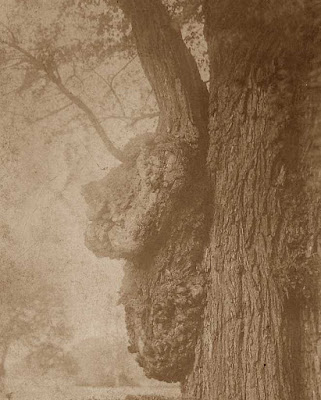 |
| The Lion Tree |
The growth was said to resemble the side profile of a
Lion’s Head and was much admired by Victorians, who dubbed it ‘The Lion Tree’.
It proved so popular that the track around the Mill was often
referred to by the local people as ‘Lion Avenue’.
Had I finally found the carving / similar that Laura needed to find, albeit by
pure chance?
I discussed the discovery with Laura, who immediately confirmed that she could
accept that this was what we should be looking for.
Progress, finally.
However, there was just one minor inconvenience that remained, which we needed
to overcome.
The tree (or what was left of it), had been removed in
1934 and no longer existed.
Picking up the pieces, do trees come back as ghosts? –
12th September 2019
Over the next couple of days I began to research the tree,
with the hope of finding its former location.
Over the course of our journey we’ve frequently found that it’s not the object
itself that’s important, it’s the location. Hopefully this would prove correct
in this case and Laura would find what she needed there.
I undertook an extensive search, online as well as in the reference books that
I held in my collection, for any commentary relevant to the Lion Tree.
Sadly, I found few mentions of the tree and, even fewer clues as to where it
once stood.
In total, I was able to find three clues as to its location, listed below, with
the reference text included:
1. Maldon and Heybridge in old picture
postcards – Peter Came 1st February 1994
As you pass through a five bar
gate into the grounds of Beeleigh Falls House a Gothic cottage is passed on
your right. Almost immediately opposite the cottage stood a remarkable elm
which had developed an excrescence resembling that of the head of a lion.
2. Essex Field Club:
The tree was in a hedgerow
near the entrance to Beeleigh Falls house, at Beeleigh near Maldon.
3. The website of the Chelmer Canal Trust (http://www.chelmercanaltrust.co.uk/nl31.htm)
A hundred years ago this
ancient deformed tree near Beeleigh Mill was a well-known local landmark.
The picture of the tree comes
from a photograph that is truly one hundred years old. Beeleigh mill house is
just visible at the far end of the road in the picture.
Not much to go on but, in the scheme of things, a lot
more than what we started with almost three months ago.
Positively, the descriptions of where to find the tree
appeared to be consistent. I concede that this could be as a result of sharing
the same (unknown) source, but at least it gave me hope.
Less could be said as result of putting my quest to the mercy of social media.
An appeal to the wider community
I then decided to cast my net further and seek possible assistance
from a local history page on Face book, in my own name, to avoid revealing the
true nature of my request - the page had been set up by a local historian and, in
the past, our own experiences had shown that sadly, history and the paranormal
rarely mix, so discussing the real reason for my post would not be wise at this
formative stage.
The post gained a healthy amount of interest, but only three responses with
regards to the former location of The Lion Tree.
Two of these were entirely left field, although they both
placed the tree at the same location in (Beeleigh) Abbey Chase, a side road off
Abbey Turning. A map was also helpfully included, where ‘X’ marked the spot in
true treasure map style!
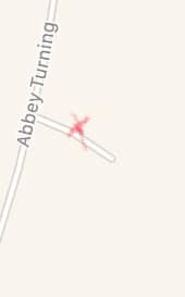 |
| X marks the spot..... |
However, the road was aligned in entirely the wrong
direction and it was impossible for the Corn Mill to be seen at the end of the
road, as indicated by the Chelmer Canal Trust Image - unless the description accompanying
the image was wrong and it was actually Beeleigh Abbey that could be seen at
the end of the track. This could not be dismissed as a possibility.
It was also curious that two complete strangers had
placed the tree a distance away, although it was, of course, entirely possible
that the information had again originated from the same source
Then, the next day, there was a final reply that
confirmed that the tree had actually been situated in the area that the reference
texts had indicated.
I appeared to be going around in circles, there was
clearly only one way to clear this up, we needed to pay another visit to the falls
and attempt to search for the location, hinted at in the Chelmer Canal Trust
image.
Additional Interest? – 13th September 2019
Friday the 13th, a full moon too.
Before we could decide on a suitable date for another trip, on the early
morning magazine programme on Radio Essex, the news broke that The Cage, in
nearby St Osyth, had finally been sold (Subject To Contract), after spending
over ten years on the market, for sale.
We had a research interest in The Cage, so whilst this
was newsworthy to us, what really caught my ear was the Paranormal ‘Team’
featured on the show to discuss the sale, briefly mentioned that they’d spent
the previous evening at Beeleigh Locks and found it very interesting, although
they didn’t expand much further on this during the broadcast.
Three months of nothing and now Beeleigh Locks appeared to be the hot topic of
the moment.
Reflection
In the days that followed, I re-examined the information
that Laura had picked up in an attempt to glean any information from it.
Hunting the Lion – 25th September 2019
With Laura tied up for most of the day, I decided that it
was time to visit the locks to try and locate the (former) Lion Tree without
her.
Critics could levy that it would’ve been better to search for the tree with
Laura, for us this was not essential – after all, Laura was only required to go
to the location, not find it.
In addition, Laura is not the most patient soul you will ever have the pleasure
of meeting, so searching alone would allow a thorough, focused examination of
the area by myself, increasing the chances of finding it.
Sitting down to re-examine the scantest of hints available to me, I felt that
there were only two real clues:
1. The
short paragraph from Peter Came’s book, that stated passing through a gate into
the grounds of Beeleigh Falls House, a Gothic cottage is visible on the right,
where the Lion Tree is almost immediately opposite; and
2. The
image from the Chelmer Canal Trust website, that showed the tree to the near
left, with a track stretching off into the distance, where a tantalising
glimpse of a left turn could be seen and, Beeleigh Corn Mill in the far
distance, straight ahead.
It is often said that a picture speaks a thousand words, although
after 100 years or so, I conceded that the effectiveness of the words could be
far less.
There was little else that I could do so sitting at my desk, so with rucksack,
camera and umbrella in hand, off I ventured into the dull, dreary morning, to
seek out my targets – Abbey Chase, on the approach to Beeleigh Abbey, as suggested
by the history group on Face book page and, where I calculated the tree to have
been located, using the historical clues, nearer to the Victorian Corn Mill, that
was also supported by a solitary Face book user.
False Leads...
Approaching Abbey Chase, it became evidently clear that this
was not the true location.
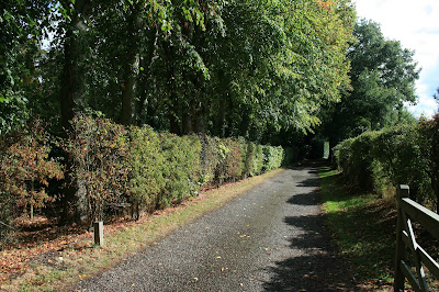 |
| Abbey Chase, NOT the former home of the Lion Tree |
As previously established, it was facing entirely the
wrong direction and, in addition, had not got the length indicated by the
Chelmer Trust image and the Abbey could not be seen, if indeed this was the
building incorrectly identified in the image.
One down, one to go and, quietly
satisfied that this was not the location, I continued my walk along what was
becoming a single track road, each step taking me nearer to the Corn Mill.
Onwards to the
Gothic Cottage
As I walked, I kept an eye out for any ‘Gothic Cottages’, preferably to my
right. Rising out of the tree line, albeit to my left, was a detached property,
painted white.
Did it look Gothic? I took some photographs, but didn’t
really think so. Besides, it would have represented the largest cottage that I’d
ever seen, if I was entirely honest.
Just ahead I could see a bend in the road; I knew that I was nearing the Mill.
I was running out of potential locations fast, I calculated there was little
road left, reducing my chances of locating the tree.
As I walked towards the bend, I spotted two properties
getting ever nearer.
To the right, a large dwelling, appearing to be of no great age and, almost
opposite on the left hand side, almost on the far bend, a small square
building, barely visible through the thick hedgerow, overlooking the River
Blackwater.
This appeared promising, or was I just reaching the end
of my journey regardless.
Reaching the bend, I peered through the hedgerow and
strained for a clear view of the cottage. It was barely visible.
I noticed the entrance to the property a short distance on, so hopeful of a
better view, I walked to the gate only to be faced with the same issue – a very tall hedge.
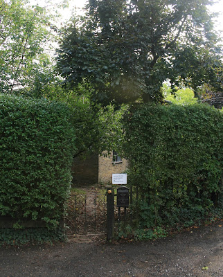 |
| The Gothic Cottage, a little shy, preferring to hide behind the hedge. |
Looking over the gate, I studied the panorama. I could see a bit more of the
property, although still not able to view it in its entirety. It didn’t particularly
look that gothic, but I had to recall the meaning of the term back in the 1920’s,
which was a lot less dramatic than the present day meaning.
Not wishing to invade the owner’s privacy and enter the gate, I contented myself
with a couple of photographs from the road, which returned fine examples of
Essex shrubbery.
Task completed, I turned to look along the road. There, at the end of the
stretch was the Mill, to the right, with Beeleigh Falls house just in front,
further to the right.
The ‘Lion Tree’
After 100 years the scene was not as tight as it appeared in the Chelmer Canal Trust’s photograph but, it wasn’t that
dissimilar either. I was almost there.
Recalling Peter Came’s words “...a Gothic cottage is passed on your right. Almost immediately
opposite the cottage stood a remarkable elm which had developed an excrescence
resembling that of the head of a lion.”, it appeared more than being almost
there. I’d found it – the location of the Lion Tree.
Opposite the gothic cottage, was the entrance to a field, which clearly explained
why the tree was photographed from that position.
The Lion Tree was located next to the entrance to the
field, if the photographer had stood just a couple of inches further back, they
would have included the entrance gate in the photograph, so, to save themselves
having to crop the image later, they simply positioned the shot so the gate
wasn’t visible.
 |
100 years on and still no yellow lines, the Lion Tree would have
been located in the same spot as the tree in the left of the picture. |
Inspecting the area more closely and taking a few photographs for future
reference, I saw that the Lion Tree would have stood on the edge of a ditch,
between the ditch and the road, which was now really a single vehicle track.
Examining the Chelmer Trust Image closely, it was
possible to make out a ditch seemingly running alongside the length of the
road, behind the hedge where the Lion Tree had been located.
The edge of the ditch had numerous small trees and
saplings near to where the Lion Tree would have stood.
Inadvertently, the ditch had proven the final key in finding the Lion Tree.
Inspecting the trees, I was able to identify them as Elms
from the leaf samples I took – perhaps putting to bed the modern day dispute as
to what type of tree the Lion Tree was. Only one of the old references had
stated that it was an Elm and the general lack of identification since had led
to open discussions as to what the tree actually was, with many choosing to favour
the theory that it was an Oak, for no logical reason.
Admittedly, without a sample of the tree available, there would still be some
element of doubt but, the fact that the immediate area was peppered with young Elm
trees was probably as good as we were going to get a hundred years or so later.
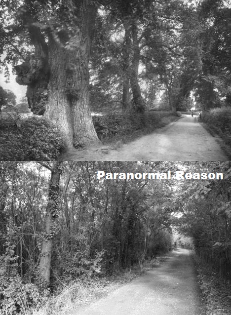 |
Top - the Lion Tree in it's prime
Bottom - the same scene today |
I had found the location of the Lion Tree, all that was needed next was for
Laura to visit.
However, that's another story.
Perhaps.